Salinity in the Venetian Lagoon is not a single fixed value across the basin. It varies spatially between the freshwater-influenced northern margins and the marine-dominated waters near the tidal inlets, and it shifts seasonally in response to river discharge, evaporation, and the strength and timing of tidal exchange. Understanding this gradient is central to interpreting the distribution of aquatic life within the lagoon.
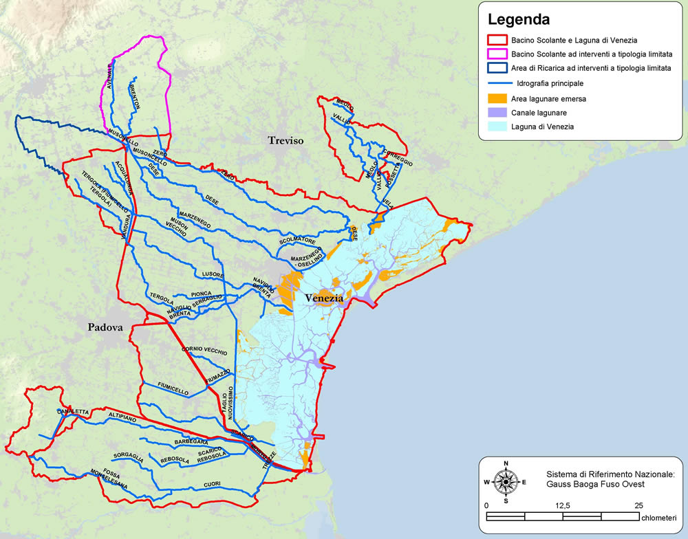
Freshwater Sources and Their Distribution
Several rivers and drainage canals discharge into the lagoon or into the transitional zone at its margins. The principal freshwater inputs arrive in the northern portion of the basin through rivers including the Dese, Zero, and several smaller drains originating in the Venetian hinterland. The industrial area of Porto Marghera contributes cooling water returns and drainage flows from the western margin.
These inputs are seasonal. Spring snowmelt and autumn rainfall produce peak discharge periods that temporarily depress salinity in the northern and western lagoon. In dry summers, reduced river flow combined with elevated evaporation from shallow water bodies causes salinity to rise in areas that are poorly connected to tidal exchange.
Tidal Forcing and Adriatic Influence
The Adriatic Sea, with salinity values generally in the range of 37–38 PSU, exerts a marine influence on the lagoon through the three tidal inlets. Each incoming tide carries salt water into the basin; each outgoing tide flushes a mixture of lagoon and river water back to sea. The degree to which this exchange renews individual parts of the lagoon depends on the geometry of the tidal channels connecting them to the inlets.
Areas near the Lido inlet, which is the largest of the three and serves the northern and central basin, experience relatively efficient tidal flushing. Areas in the northern lagoon that are separated from the main tidal channels by shallows have longer water residence times. In these zones, freshwater inputs accumulate more effectively between tidal cycles.
Water residence time — the average duration a parcel of water spends within the lagoon before being exchanged with the sea — varies considerably across the basin. Some enclosed bays in the northern lagoon have residence times measured in weeks rather than days, making them sensitive to accumulation of dissolved substances from land runoff.
Spatial Zonation
The salinity gradient in the lagoon runs roughly from lower values in the north and northwest (close to river inputs and more isolated from marine inlets) toward higher values near the southern inlet at Chioggia and along the main tidal channels. The lagoon's central zone, influenced by both the Malamocco inlet and runoff from mainland industrial areas, occupies an intermediate position in this gradient.
Northern Lagoon
The northern lagoon, which includes the islands of Torcello and Burano and several uninhabited mudflat areas, receives relatively high freshwater input compared to its area. Salinity in this sector can drop to low values during river flood periods. This zone is historically associated with aquatic vegetation communities adapted to brackish conditions, including stands of Zostera and Ruppia species.
Central and Southern Lagoon
Moving toward the Malamocco and Chioggia inlets, tidal exchange efficiency increases and salinity values remain closer to marine levels across most of the tidal cycle. The deep navigation channel at Malamocco was constructed to allow oil tankers and industrial cargo vessels to reach Porto Marghera; the hydrodynamic effect of this channel extends well beyond the immediate channel corridor.
Seasonal Patterns
Long-term monitoring data collected by ARPA Veneto at fixed measurement stations across the lagoon shows that the range of salinity variation is not uniform across the basin. Stations in the northern lagoon exhibit wide seasonal amplitude, whereas stations near the tidal inlets show relatively stable values that more closely track Adriatic conditions.
The timing of maximum and minimum salinity values also varies by location. Northern stations typically record lowest salinity in spring, coinciding with peak river discharge, and highest salinity in late summer when river flows are low and evaporative concentration is at its peak. Inlet-adjacent stations show less seasonal movement and are more influenced by interannual variability in Adriatic conditions.
| Lagoon Zone | Primary Forcing | Approximate Salinity Range (PSU) | Seasonal Pattern |
|---|---|---|---|
| Northern (Torcello area) | River input dominant | 5–30 | Low spring, high late summer |
| Central (Malamocco corridor) | Tidal and industrial inputs | 20–36 | Moderate seasonal variation |
| Southern (Chioggia inlet) | Marine exchange dominant | 30–38 | Low seasonal variation |
| Enclosed bays (NW sector) | Low tidal exchange | 1–35 | Wide range, event-driven |
Ecological Consequences of Salinity Zonation
Salinity is a strong environmental filter for aquatic organisms. Species that can tolerate a wide range of salinity values (euryhaline species) are found across the lagoon. Species with narrow salinity tolerances are restricted to particular zones. This biological sorting along the salinity gradient is a fundamental structuring process in the lagoon's ecology.
Fish assemblages in the lagoon include both resident species and migrants that use the lagoon as a nursery or feeding ground at certain life stages. Many economically important species — including sea bass (Dicentrarchus labrax), mullet (Mugil spp.), and eel (Anguilla anguilla) — are euryhaline and capable of using all parts of the lagoon. Strictly marine species tend to be concentrated near the inlets.
Aquatic macrophyte communities are particularly sensitive to salinity. Zostera marina (common eelgrass), which forms structured meadows in lower salinity areas, has declined substantially in the lagoon over the twentieth century. Loss of seagrass meadows removes habitat structure that benefits juvenile fish and invertebrates, and reduces the stabilising effect of vegetation root systems on soft sediment.
Monitoring Infrastructure
ARPA Veneto operates a network of water quality stations in the lagoon that record salinity (conductivity) along with other physicochemical parameters. CNR ISMAR has contributed to understanding salinity dynamics through research campaigns involving Lagrangian drifters, CTD profiling, and numerical modelling of the lagoon hydrodynamics. The CORILA consortium (Consorzio per la Gestione del Centro di Coordinamento delle Attività di Ricerca inerenti il Sistema Lagunare di Venezia) has coordinated multi-institutional research on these topics over several decades.
References
- Solidoro, C. et al. (2004). Understanding dynamic of biogeochemical properties in the lagoon of Venice: Evidence from numerical modelling. Ecological Modelling.
- ARPA Veneto — Annual water quality monitoring reports for the Venetian Lagoon. arpa.veneto.it
- CNR ISMAR — Venice office research publications. ismar.cnr.it
- CORILA — Research coordination for the Venetian Lagoon system. corila.it